q4WsCvLajdd4

Relative dating establishes the sequence of geological events without assigning an exact numerical age. It is a foundational skill because rocks often preserve a clear order of formation even when no suitable material is available for radiometric dating.

The science behind the subject
The principles of superposition, original horizontality, cross-cutting relationships and inclusions help establish relative order. For example, a fault that cuts a rock unit must be younger than the unit it displaces, while a pebble enclosed in a conglomerate predates the sediment that surrounds it.
What the evidence can tell us
Geologists combine these principles with fossils, mapped contacts and stratigraphic sections. Correlation between distant sites is strengthened when several independent markers agree, rather than relying on one visual similarity.
A practical way to observe it
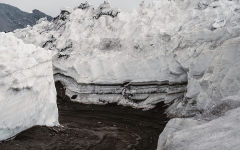
Draw a simple event sequence from an outcrop: deposition, tilting, faulting, erosion and later burial. Label which relationships are directly observed and which are inferred from the geometry.
Important limits and misconceptions
Relative age does not tell how many years separate events. An unconformity may represent a short pause or an immense interval, so numerical dating is needed when the duration matters.
Why this matters
Relative dating turns complex outcrops into an ordered history. It is essential for mapping, resource studies and interpreting how landscapes and tectonic systems evolved.
Putting observations into context
A sound geological interpretation combines field relationships, maps and analytical evidence. A specimen provides information about texture and minerals, while a regional map shows how an exposure relates to surrounding units. Laboratory measurements can test ideas that are not visible to the eye, and clear notes make the reasoning easier for another reader to review.
From evidence to explanation
Geologists often compare more than one possible explanation before choosing an interpretation. A familiar shape or colour can have several origins, and new measurements may change the preferred model. This is how Earth science improves: claims are made testable, uncertainty is described and interpretations are revised when additional evidence becomes available.
Questions for further study
Compare examples from different climates, rock types and tectonic settings. Ask whether the same process produces different landforms under different conditions, and whether a similar-looking feature could have formed by another mechanism. National geological surveys and university teaching resources provide useful maps, datasets and case studies for further reading.
Estimated reading time: 4–6 minutes.